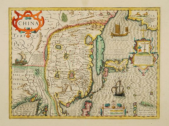
Publisher: MERCATOR,G./ HONDIUS,J.
Title: China.
Published in: Amsterdam, 1633
Important map of China. Besides China, the map depicts Korea as an elongated island and Japan from the Teixeira model of 1595. Decorated with strapwork cartouches, a European and Chinese ship, a sea-monster and wheeled wind-machines.
In one of the cartouches a scene from the a Japanese persecution of a Christian missionary and converts in this period, probably a reference to the martyrdom's in Nagasaki in 1597.
The name most associated with advancing cartography as a science during this formative period is the Flemish geographer Gerard Mercator who helped free geography from its Ptolemaic infuence by his prodigious contributions in the production of globes, maps, map projections, and atlases. (from Library of Congress text)
Note: It is understood that there are many rivers coming from the Himalaya. On this map they appear to come from one circular source - it has something to do with Xanadu and the religious idea that there is a source for life...(ref conversation with librarian in Nasjonal biblioteket Oslo).
The big rivers in China is poorly represented compared to the cery accurate stone map from China depicting both the Yellow river and Yangtze with great accuracy as early as 1136...
No comments:
Post a Comment